How Westwood Floodlight™ Transforms Flood Risk Screening

Enhancing Site Selection
Flood risk is a major factor in renewable energy site selection, impacting feasibility, permitting, and design. Currently, early-stage flood risk assessments often rely on outdated or incomplete FEMA maps or require expensive, time-consuming, comprehensive hydrologic studies.
Westwood Floodlight™ addresses this gap with a streamlined flood risk assessment tool for renewable energy development. It combines two-dimensional (2D) hydrologic and hydraulic modeling with publicly available datasets to deliver rapid, scalable, and cost-efficient insights, empowering project teams to make quicker, data-informed decisions earlier in the process.
Introducing Westwood Floodlight™
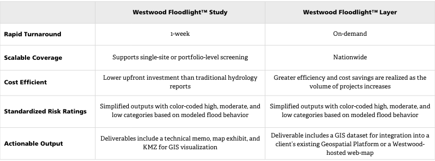
Westwood Floodlight™ is a preliminary flood risk screening tool designed for early-stage development and site comparison. Westwood Floodlight™ provides two products to best meet developers’ needs:
- Westwood Floodlight™ Study is a project-based flood risk assessment prepared and reviewed by Westwood’s experienced Water Resources team. Its low cost and quick turnaround make it a great choice for reviewing single or multi-project portfolios.
- Westwood Floodlight™ Layer is a comprehensive nationwide flood risk map covering the entire lower 48 states. It provides a GIS dataset or web map that allows for on-demand, instantaneous review of an unlimited number of project sites. The layer is ideal for developers exploring many potential project areas.
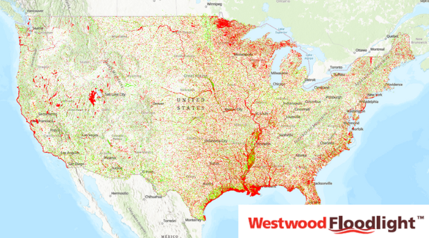
Westwood Floodlight™ Layer National Coverage
Both products provide a user-friendly, straightforward system with classifications for high-, moderate-, and low-flood risk areas. This classification is based on simulated flood depth and flow velocity and was specifically created to help developers identify risk constraints before advancing to detailed design or permitting.
Key Benefits
How Westwood Floodlight™ Works
Hydrologic Modeling
Each Westwood Floodlight™ product models the project area using advanced hydrologic modeling tools, simulating a 100-year, 24-hour rainfall event based on NOAA Atlas 14 precipitation data.
The model integrates:
- Topography: USGS 3DEP
- Land Cover: USDA 2021 NASS Crop Layer
- Soils: SSURGO, STATSGO, gNATSGO
- Rainfall Inputs: NOAA Atlas 14 and Atlas 2 (PNW)
Flood Risk Analysis
Westwood Floodlight™ products use sophisticated hydraulic simulations to assess flood depth and velocity, correlating them with risk thresholds informed by our renewable energy expertise. By classifying areas into high-, mediummoderate-, and low-flood-risk zones, we provide actionable insights for site selection and design. This helps developers visualize potential impacts and make informed decisions early in the planning process.
Westwood Floodlight™ versus FEMA Assessments
Westwood Floodlight™ offers an enhanced approach to flood risk screening, surpassing traditional FEMA assessments. Utilizing advanced 2D modeling and high-resolution elevation data, Westwood Floodlight™ aligns with FEMA-modeled areas while providing deeper insights into regions lacking detailed FEMA analysis.
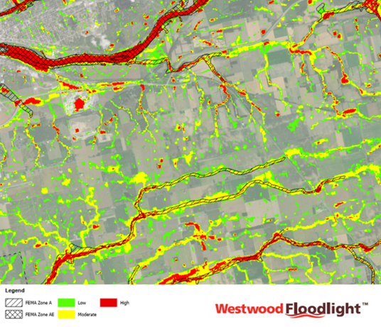
Westwood Floodlight™ layer comparison to FEMA Flood Data
Integration for Hydrology Studies
The integration of Westwood Floodlight™ into detailed hydrology evaluations serves as a crucial building block for both preliminary and final studies. By leveraging insights from Westwood Floodlight™, our team reduces the time required for these studies, enhancing workflow efficiency and accuracy. This foundational tool ensures clients receive reliable hydrology evaluations, setting the stage for successful project development.
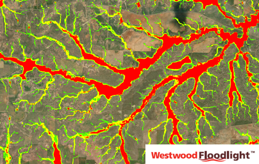
Westwood Floodlight™ results in an area with no FEMA coverage
Feasibility with Westwood Floodlight™
Westwood Floodlight™ is designed for use at the feasibility and planning stage, including:
- Renewable energy site selection and real estate screening
- Initial layout and concept planning
- Constraint mapping for pre-ALTA or environmental due diligence
Flood risk remains one of the most critical siting constraints in renewable energy development. By leveraging automated, geospatially accurate, and scalable flood modeling, Westwood Floodlight™ reduces the uncertainty of early-phase development and enhances the efficiency of site comparisons.
Westwood Floodlight™ is a purpose-built solution for developers and owners seeking risk mitigation on site selection that is fast, accurate, and within budget. Contact our Water Resources team to learn how Westwood Floodlight™ can support your flood risk assessment strategy for renewable energy development.
. . .
Our Westwood digital solutions are designed to empower our clients with cutting-edge solutions tailored to meet their unique needs. From advanced energy grid transformation to resilient infrastructure design, our products are crafted with the latest technology and a commitment to excellence. Our innovations are here to illuminate your path to success with confidence and accuracy.